


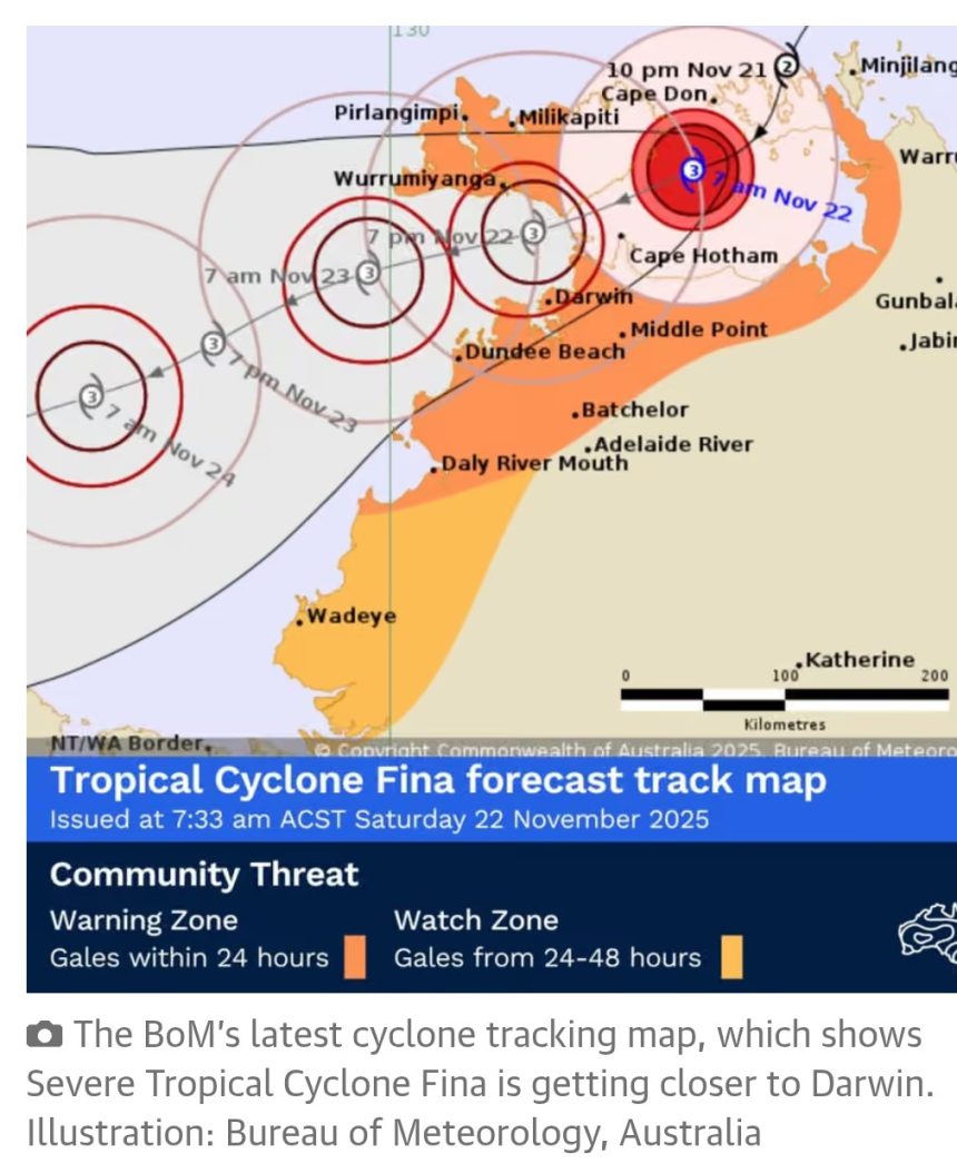
Severe Tropical Cyclone Fina has intensified to a category three system as it closes in on Darwin today, making it the first cyclone of that strength in Australian waters in November in 20 years.
“We are re-accommodating impacted customers on alternative services, and planning additional flights on Sunday to help get customers on their way when it is safe to do so,” the spokesperson said.
Darwin airport advised all travellers to check with their airline regarding flight delays or cancellations.
The Australian defence force was on standby to assist if requested by the Northern Territory government, according to MP Luke Gosling, the special envoy for defence, veterans affairs and northern Australia.
Speaking in South Africa, Anthony Albanese urged people in the cyclone’s path to look after themselves and others.
“My thoughts are with people at this time and also with the emergency service workers and others who will be working hard,” the prime minister said.
Northern Territory Emergency Service issued an emergency warning for Darwin to Cape Hotham, including parts of the Tiwi Islands around Wurrumiyanga, advising households to “take shelter now”.
A cyclone watch and act alert for other affected areas including parts of the Tiwi Islands including Pirlangimpi and Milikapiti, Daly River Mouth to Cape Don, and inland to Batchelor.
Royal Darwin hospital has issued a code brown, according to NT News, a nationally recognised emergency alert which streamlines emergency management systems.
A spokesperson for NT Health said local emergency response plans were in place across all regions to ensure essential health services continued safely and that staff were supported as weather conditions change.
Hospitals and health facilities in the Top End remained fully operational, with services being continually assessed according to updated advice from emergency management agencies.
“Patients with scheduled treatments or surgeries should continue to attend appointments unless they have been contacted directly by their healthcare team,” the spokesperson said.
People watch Severe Tropical Cyclone Fina roll in at Nightcliff jetty, just outside Darwin CBD. Photograph: (A)manda Parkinson/The Guardian
Severe Tropical Cyclone Fina was about 85km to the north-east of Darwin on Saturday morning.
It was moving southwest at about 9km/h, said senior meteorologist Dean Narramore, from the Bureau of Meteorology, at 9.30am, with destructive winds, torrential rain, dangerous flooding, waves and storm tide, and possible disruption to essential supplies like electricity, water and gas.
Households in affected areas were advised to enact their emergency plans immediately.
Narramore said conditions had started to intensify around the core of the cyclone, with winds up to 185km/h. “That’s the inner eye wall, that circle you can see on radar where there’s not rainfall, and the rain’s circulating around that.”
“Some of our island locations have seen 200 millimetres in the last 24 hours,” Narramore said. Although the bulk of the rain was still to come, according to the BoM.
“We’ve already seen around 20 or 30mm around Darwin and many other areas. That rain is going to continue to increase as we move through today and tonight.”
High tide in Darwin was expected around 8pm, Narramore said, which would coincide with the worst conditions of the cyclone, particularly for coastal areas – expected to peak from about 5pm to 10pm.
“In the coming days, we’re likely to see a continuous Category 3 status through Sunday and Monday as it heads towards the northern Kimberley coast,” Narramore said.
The last cyclone to reach category three in November was tropical cyclone Bertie-Alvin in 2005, according to Weatherzone. Fina was also the equal earliest tropical cyclone to make landfall, as it briefly crossed the Cobourg Peninsula on Friday night before moving back over the ocean.
– with AAP